Project Description
Our research on West Nile virus (WNV) in the Northern Great Plains has documented regional associations of human disease with climatic gradients and land use patterns (Wimberly et al. 2008). We also used a state-level dataset of geocoded West Nile virus cases (Wey et al. 2009) to examine landscape level associations with land cover, soils, and hydrological characteristics (Chuang et al. 2012) . We found that these environmental relationships reflected the underlying influences of weather and land cover on the abundance of Culex tarsalis, the mosquito vector in the region (Chuang et al. 2011). Based on these results, we developed a model to predict the relative risk of human WNV across the NGP based on remotely sensed metrics of accumulated vegetation greenness, temperature, and moisture during the WNV amplification season (Chuang and Wimberly, 2012a). We also used estimates of air temperature, vegetation opacity, and fractional water content derived from satellite microwave remote sensing to model spatial and temporal patterns of climatic suitability for Culex tarsalis and Aedes vexans in eastern South Dakota (Chuang and Wimberly 2012b).
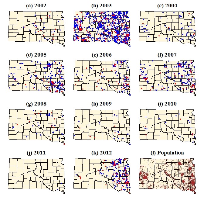
Dot density map of WNV cases and human population in South Dakota (Wimberly et al. 2013). Red dots represent WNV neuroinvasive disease and blue dots represent WNV fever. Brown dots represent total population with one dot per 100 people.
Following the nationwide resurgence of WNV cases in 2012, we quantified the spatio-temporal patterns of WNV cases in South Dakota to provide a basis for future modeling efforts (Wimberly et al. 2013). We also analyzed the associations of climate variation and WNV cases in three regions affected by the 2012 WNV outbreak and found consistent positive effects of winter and summer temperature anomalies on WNV rates (Wimberly et al. 2014). These findings were used to develop forecasting models of WNV risk that integrate lagged effects of environmental variables with data on recent mosquito infection rates (Davis et al. 2017; 2018). To generate a statewide WNV risk map for South Dakota, we developed a predictive spatial model based on associations of geocoded human cases locations with topography, land cover, and remotely-sensed environmental indices (Hess et al. 2018). We are continuing our research on the environmental determinants of WNV in South Dakota and extending it to new areas including Oklahoma, Louisiana, and Michigan. This work has provided the foundation for the Arbovirus Monitoring and Prediction (ArboMAP) system, a software package that automatically ingests gridded meterological data, human case data, and mosquito infection data to estimate current WNV risk levels and forecast future risk throughout the transmission season.
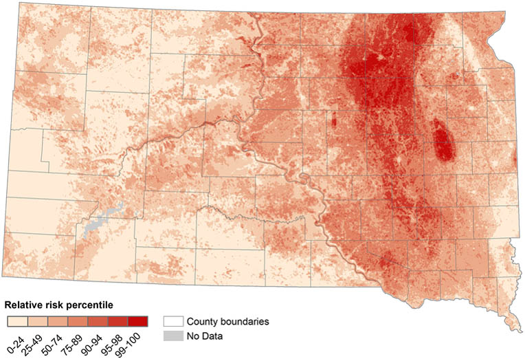
Predicted map of relative WNV risk in South Dakota based on the associatiosn of geocoded case locations with topography, land cover, and remotely-sensed environmental indices. Values range from 0 for no risk to 1 for the highest risk level in the state (Hess et al. 2018).
Partner Organizations
- South Dakota State University
- South Dakota Department of Health
- City of Sioux Falls Health Department
- City of Aberdeen Parks Department
Publications
- Vincent, G. P., J. K. Davis, M. C. Wimberly, C. D. Carlson, and M. B. Hildreth. 2018. Permethrin susceptibility for the vector Culex tarsalis and a nuisance mosquito Aedes vexans in an area endemic for West Nile virus. BioMed Research International, Article ID 2014746.
- Davis, J. K., G. P. Vincent, M. B. Hildreth, L. Kightlinger, and M. C. Wimberly. 2018. Improving the prediction of arbovirus outbreaks: a comparison of climate-driven models for West Nile virus in an endemic region of the United States. Acta Tropica 185: 242-250.
- Davis J. K., Vincent G. P., Hildreth M. B., Kightlinger L., Carlson C., and M. C. Wimberly. 2017. Integrating Environmental Monitoring and Mosquito Surveillance to Predict Vector-borne Disease: Prospective Forecasts of a West Nile Virus Outbreak. PLoS Currents Outbreaks. 2017 May 23. Edition 1. doi: 10.1371/currents.outbreaks.90e80717c4e67e1a830f17feeaaf85de.
- Wimberly, M. C., A. Lamsal, P. Giacomo, and T. Chuang. 2014. Regional variation of climatic influences on West Nile virus outbreaks in the United States. American Journal of Tropical Medicine and Hygiene 91: 677-684.
- Wimberly, M. C., P. Giacomo, L. Kightlinger, and M. B. Hildreth. 2013. Spatio-temporal epidemiology of human West Nile virus disease in South Dakota. International Journal of Environmental Research and Public Health 10: 5584-5602.
- Chuang, T., C. W. Hockett, L. Kightlinger, and M. C. Wimberly. 2012. Landscape-level spatial patterns of West Nile virus risk in the northern Great Plains. American Journal of Tropical Medicine and Hygiene 86: 724-731.
- Chuang, T., G. M Henebry, J. S. Kimball, D.L. VanRoekel-Patton, M. B. Hildreth, and M. C. Wimberly. 2012. Satellite microwave remote sensing for environment modeling of mosquito population dynamics. Remote Sensing of Environment 125: 147-156.
- Chuang T., and M. C. Wimberly. 2012. Remote Sensing of Climatic Anomalies and West Nile Virus Incidence in the Northern Great Plains of the United States. PLoS One 7:e46882.
- Chuang, T. M. B. Hildreth, M. B., D. L. VanRoekel, and M. C. Wimberly. 2011. Weather and land cover influences on mosquito populations in Sioux Falls, South Dakota. Journal of Medical Entomology 48: 669-679.
- Wey, C. L., J. Griesse, L. Kightlinger, and M. C. Wimberly. 2009. Geographic variability in geocoding success for West Nile virus cases in South Dakota, USA. Health & Place 15: 1108-1114.
- Wimberly, M. C., M. B. Hildreth, S. P. Boyte, E. Lindquist, and L. Kightlinger. 2008. Ecological niche of the 2003 West Nile virus epidemic in the northern Great Plains of the United States. PLoS One 3: e3744.